A Guide to Climbing Ruth Mountain (Washington)
Ruth Mountain is a classic, glaciated climb suitable for beginner mountaineers.

Description
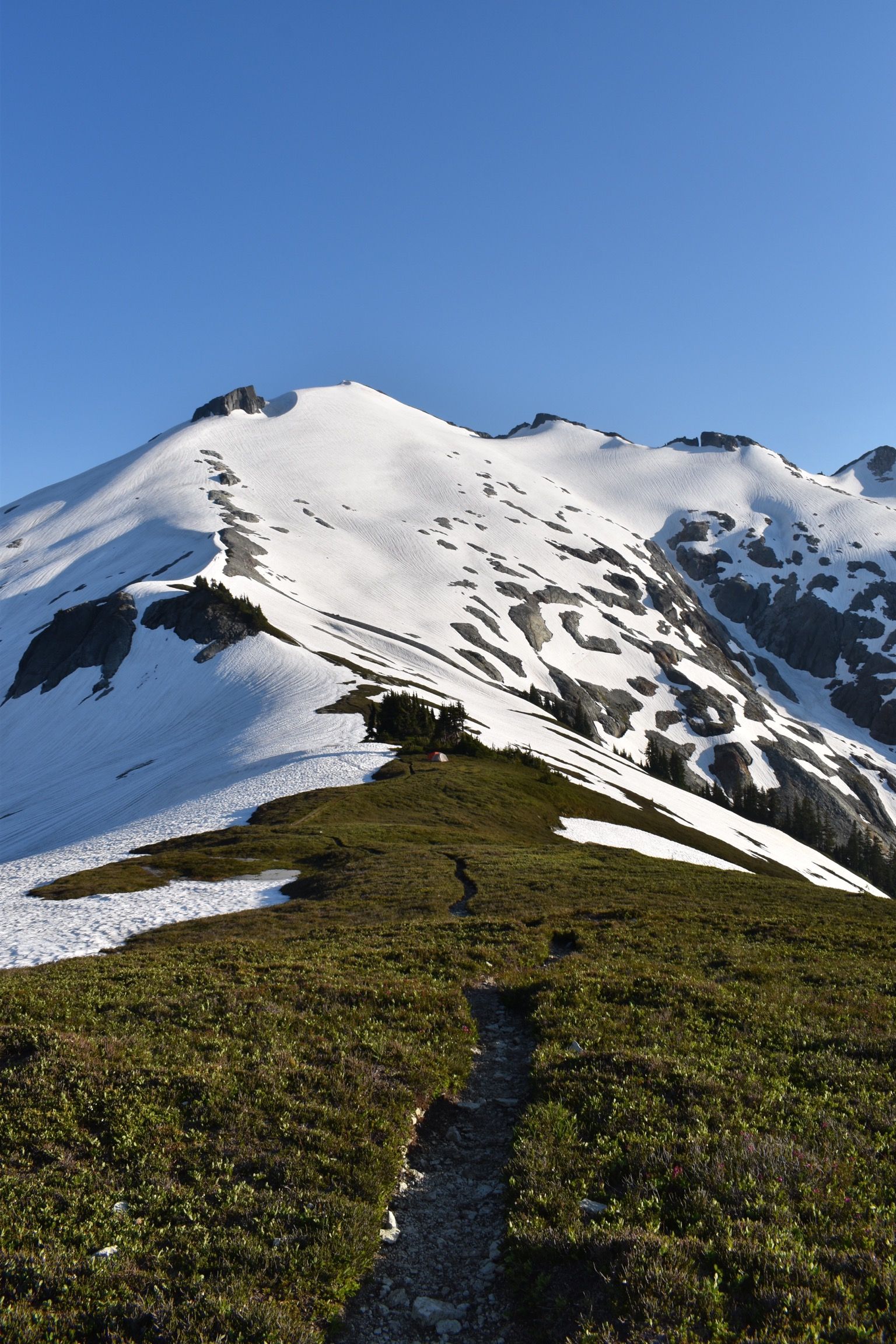
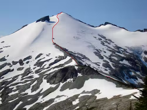
Ruth Mountain is a classic, glaciated climb suitable for beginner mountaineers. The rocky summit has beautiful alpine vegetation and 360° views of Icy Peak and Mount Shuksan.
Most of the approach is located within Mt. Baker Wilderness. The hike through the valley is gorgeous but exposed, so remember sunscreen! The summit is located within North Cascade National Park.
Read my July 2022 trip report here.
Round Trip Stats
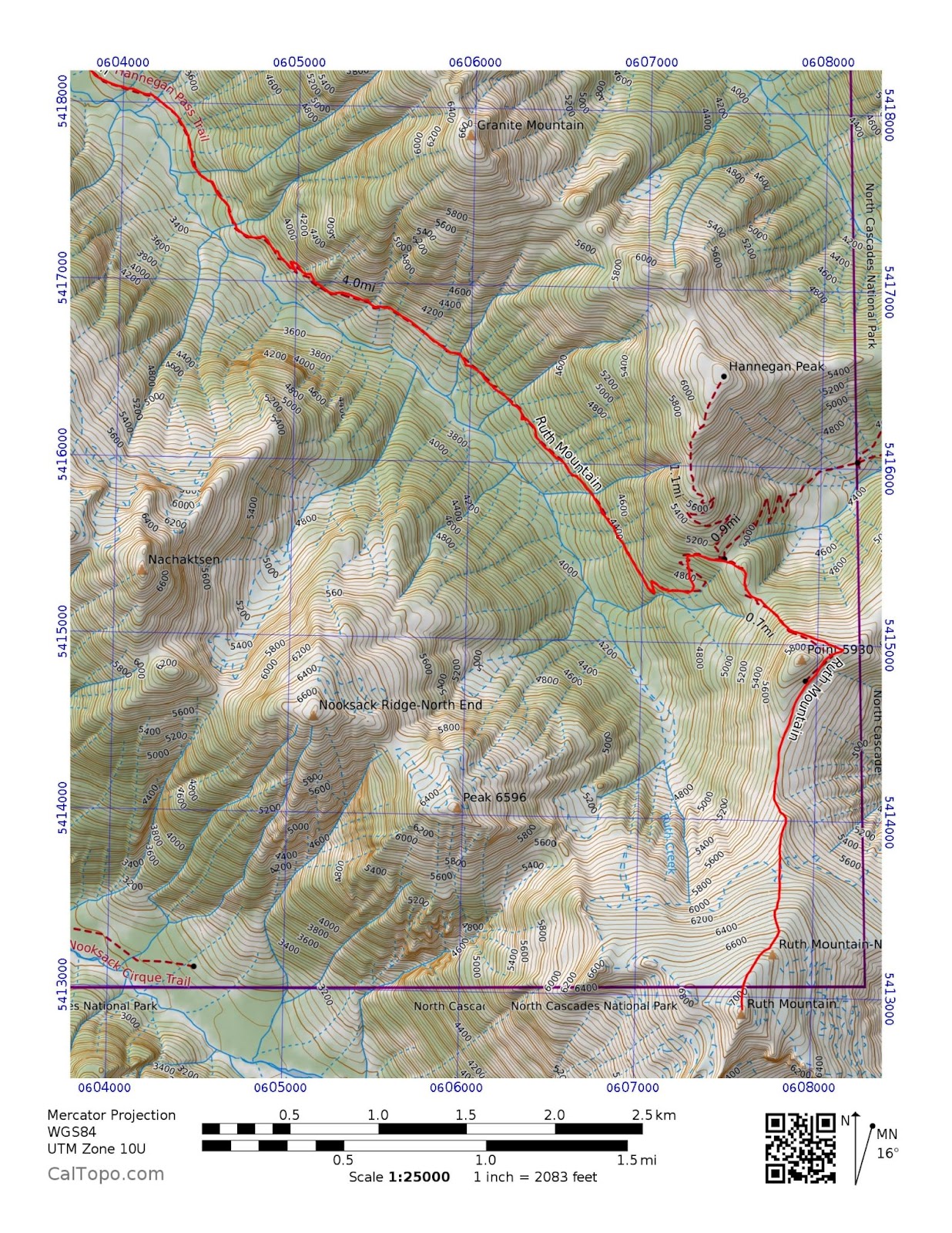
Mileage: ~12 miles
Elevation Gain: ~4200 ft
Route Type: Out-And-Back
Difficulty: Basic mountaineering skills and strong physical fitness are required. You should be sufficient in crevasse rescue, self arrest, steep snow travel, and avalanche rescue/awareness skills.
Trip Length: 1-2 days
Trailhead: Hannegan Trailhead (Coordinates: 48.9101, -121.5927). Northwest Forest Pass/fee required.
Optimal Season: Late spring, summer, fall
Early season climbs will face increased avalanche danger and trail hazards (such as sketchy snowbridges over streams). Late season might bring wildfire smoke, bare glacial ice, and difficult glacier navigation (the glacier may be broken up with crevasses and the snowbridges across them may have melted out). There is also a higher risk of poor weather in the spring or fall compared to summer.
The optimal time to climb Ruth Mountain (least hazards and best chance of good weather/views) is July-August. The best time to ski Ruth Mountain is May-June.
This area has a lot of avalanche danger. Hannegan Pass Road 32 enters avalanche terrain after Goat Mountain Trailhead. The approach hike crosses many avalanche chutes. The traverse around Point 5930 crosses avalanche-prone slopes. Ruth Mountain itself requires travel through avalanche terrain. If you attempt Ruth in the spring or early summer, you will probably have to clamber across plenty of avalanche debris.
Water Sources
There are plenty of streams on the Hannegan Pass Trail approach. Hannegan Camp has a great stream. There is one good stream between Hannegan Camp and Hannegan Pass and we didn't see any good water above that. If you camp on Ruth Arm or above, carry up enough water or collect glacial runoff/melt snow.
Camping
The most popular camp sites are Hannegan Camp, Ruth Arm, and Ruth's summit itself. An overnight permit is required for camping on the summit.
Hannegan Camp:
- Definitely a busy area, but there were still open sites early on a Saturday evening in late July.
- No campfires.
- Has a great stream.
- The camp sites are sheltered.
- Pets allowed. If traveling with a dog, time your trip wisely. The hike through the valley is hot and exposed.
- Great stars.
- Known for bears, so proper food storage is essential (bear can, Ursack, etc.). There aren't good trees for a PCT style bear hang nearby.
- Hannegan Camp and Hannegan Pass have toilet facilities.
Ruth Arm:
- Sensitive alpine environment. The best practice for camping on Ruth Arm (and in the alpine in general) is to camp on snow or an established site to protect the fragile vegetation. Wag bag your waste.
- The closest logical camp site without a NCNP overnight permit.
- Spectacular 360° views of Nooksack Ridge, Mount Baker, and Ruth Mountain. Amazing views of the stars, sunrise, and sunset.
- No campfires.
- No water.
- You have to carry your overnight pack up (and down) the muddy gully and it sucks.
- Pets allowed (but most would likely need assistance with the gully).
- Known for bears, so proper food storage is essential (bear can, Ursack, etc.). There aren't good trees for a PCT style bear hang nearby.
- The ridge is exposed and can be much colder and windier than Hannegan Camp. There is a sheltered, established site in the trees but come prepared in case it is taken.
Ruth Summit:
- Permit required.
- Sensitive alpine environment. Utilize an established site to protect the fragile vegetation. Wag bag your waste. Practice proper food storage.
- Spectacular 360° views. Amazing views of the stars, sunrise, and sunset.
- No campfires.
- No water.
- You have to carry your overnight pack up (and down) the entire route.
- No pets allowed.
- The summit is exposed.
Gear List
Hiking Gear
- Cap + Sunglasses / Glacier Glasses
- Wicking Base Layer, upper and lower
- Rain / Wind Layers
- 2x pairs of Socks
- Trail Runners / Approach Shoes
- Medium-size Backpack
- Map + Compass
- Waterproof Bag w/ phone, wallet, keys
- Water Bottles (at least two) + filter or iodine
- Food
- First Aid Kit + Repair Kit
- Headlamp + Spare Batteries
- Trekking Poles
- Sun Screen and Bug Spray
- Spare Water, Shoes, Clothes (to keep in the car for the drive home)
- Phone Charger (for car)
Overnight Gear
- Stove + Fuel + Pot + Bowl + Spork
- Dry Foods for 1 night (repackaged for weight/space)
- Ursack/Food storage system
- Insulating Layers for camp
- A Change of Underwear
- Plastic Bag (for trash)
- Sleeping Bag (appropriate minimum temperature)
- Sleeping Pad (appropriate for minimum temperature)
- Tent/sleeping system
- Toothbrush, Toothpaste, Toilet Paper, Trowel
Glacier Gear
- Mountaineering Boots
- Crampons
- Ice Axe
- Lightweight Gloves
- Harness
- Climbing Helmet
- Crevasse Rescue Kit:
- Picket (Yates V, mid-clip cable is best)
- Pear Locker
- NanoTraxion on Locker
- Tibloc + Pulley on Locker
- Hollowblock / Prussik Cord on Locker
- Double Length Sling on a carabiner
- Single Length Sling on a carabiner
- Extra locker + extra carabiner
- Rope
- Season dependent: skis/snowshoes, avalanche gear (beacon, probe, shovel, etc.)